Severe storm photos
 This storm hit Joplin, Missouri last night, spawning a tornado that killed many people. The numbers are still rising as I write this.
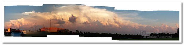
At the time, Mary remarked that the clouds looked pretty. And they do. But their fluffy appearance comes from powerful updrafts. They looked almost like steam boiling atop a kettle.
The view in that first photo is roughly east to southeast. I took it with the Kodak Z1285 using the camera's internal stitching software. Afterward, I corrected some of the distortion in Zoner Photo Studio, straightening that light pole in the middle but making the edges distort almost like a fish-eye lens.
The bottom photo was taken less than half an hour later. The storm stretches from east to south, growing as it moved. This was taken with the same camera with the lens zoomed to about 100 mm. They were stitched in Zoner. The right most ones are out of focus but it looks OK in the smaller sizes. The original was over 30 megs!
Labels: Joplin, kodak z1285, severe thunderstorm, severe weather, tornado, zoner photo studio
posted by Ed W at 4:43 PM
![]()
![]()


2 Comments:
Hey bro.....I heard on the news that Oklahoma city got hit by some tornados-you and the fam okay?
George asked if we were OK since tornadoes were on the ground out by Oklahoma City. For some odd reason, Blogger won't allow me to post his comment.
We're fine here in Owasso. The torndoes were out around OKC, and they lost energy as they traveled east. We had high winds, lots of rain, and a wonderful light show, but no tornadoes. I can't say I'm disappointed.
Oklahoma has an outstanding severe weather warning system and the most advanced weather radar in the country. NWS has it's research facility out near OKC. I've been to their storm chasers training, a subject that's probably worthy of a post. Maybe tomorrow, 'cause right now I'm a tired puppy.
Post a Comment
<< Home